🌏 繁體中文版
Insubong is not the only option for a granite multipitch day while staying in Seoul. Farther northeast, Seoninbong (선인봉) in Dobongsan also begins with a subway journey. Its cracks can put fists, arms and your whole body to work alongside the slabs.
This guide helps you compare Seoninbong with Insubong, plan a car-free approach and choose routes that match your crack and multipitch skills. It is for teams with outdoor belaying experience who can prepare trad protection and a descent plan.
What kind of crag
Seoninbong is a climbing cliff in the Dobong district of Bukhansan National Park, rather than another name for a Dobongsan hike. The 2012 Climb: Rock Climbing in Korea lists 37 routes here, describing granite slabs, cracks, chimneys and overhangs. That is the edition's coverage, not a current complete count.
The same guide describes it as steeper, with better friction, than Insubong. This is a useful impression of the style, not proof that every crack is easy to protect. Some lines have fixed gear; others depend on removable protection throughout.
For example, People and Mountain's 2017 feature on 주먹 쥐고 일어서, or Stands With a Fist, describes an approximately 28 m, 5.10c fist crack with no bolts on the climbing section and a need for repeated cam sizes. Climbing the same sport grade does not establish readiness for its wide crack or protection requirements.
Choose Seoninbong for crack-focused granite climbing when you can bring a trad rack and allow time for the approach and team efficiency. For a lighter rack of quickdraws and a day of short routes, compare Ganhyeon first.
When to go
The 2012 guide describes the main cliff as southeast-facing. Dry spring and autumn days are a sensible starting point for a first visit. Summer adds sun, humidity and an uphill approach. The Korea Meteorological Administration's climate overview describes the country's summer rains and cold winters; your chosen face and the day's wind still matter.
There are local exceptions. Stands With a Fist occupies a shaded cleft: the firsthand People and Mountain report describes all-day shade there. That applies to that crack and its location, not to Seoninbong as a uniformly shady summer venue.
Check thaw restrictions before fixing spring climbing dates. A 2026 notice reproduced by the Seoul Alpine Federation named Seoninbong among the Dobong-area cliffs restricted from March 23 to April 5, with possible weather-related changes. These are that year's dates, not a permanent annual calendar.
Getting there
Public transport
The official Dobong transport page, checked in October 2026, lists Dobongsan Station (도봉산역), on subway lines 1 and 7. The official FAQ gives about ten minutes on foot from the station to Dobong Visitor Support Center. That only reaches the trailhead, not the cliff.
From the entrance, follow the Dobong-area approach toward the mountain rescue station, then use your selected route's topo to identify the cliff branch. This is the approach described in the 2012 guide. Allow separately for walking uphill with ropes, route finding and breaks; an old guide's walking time is not a promise for your team. Seoninbong, Insubong and the Dobongsan hiking viewpoints are different destinations.
Driving
Locate the 도봉산역 / 도봉탐방지원센터 side and confirm that you are entering from Dobong-dong. Arriving at Songchu or another national park entrance does not put you on the same climbing approach.
Parking
Start with Seoul Facilities Corporation's Dobongsan Station transfer car park. Its page checked in October 2026 gives the address 서울시 도봉구 도봉로 955. This is paid station parking: you still walk to the trailhead and then the cliff. Confirm vehicle-height limits, current operating conditions and charges with the operator; do not assume temple grounds provide unrestricted all-day climbing parking.
Rules before you go
Check the named cliff and route. The KNPS live control page identifies the Bukhansan Dobong office's status, but a normal trail status does not establish that a climbing line is open.
This matters around 표범길 (Leopard), 박쥐길 (Bat) and 설우길 (Seolwoo). A 2025 Monthly Mountain report on rockfall and restrictions distinguished the adjacent trail's planned reopening from the undetermined reopening of climbing routes. This is a secondary report from that time, not a current closure or reopening notice. Confirm the named lines and approach with the Dobong office before planning them. They are not listed as first-visit objectives below.
Ask the Dobong office how rock use is currently handled. The general KNPS rock-use service provides an enquiry entry point, rather than proof of the exact process for every Seoninbong line. Keep access clear around temples, rescue facilities and trails, respect barriers and do not treat historical camping information as current permission.
Before climbing, prepare suitable protection, ropes and a descent topo for the chosen line. A 2017 refurbishment feature does not guarantee today's hardware, and the table's climbing lengths are not rappel-rope requirements. If sharing a descent with another team, establish the stations, rope-drop direction and waiting arrangements.
For an emergency, call 119, which the National Fire Agency's service information also covers for foreigners. Save Korean crag and route names and an offline location. Ask your own insurer about trad climbing, multipitch, search and rescue, medical treatment and repatriation; your policy controls coverage. The BMC product summary illustrates activity eligibility and exclusions, not a recommendation that Taiwan residents buy that product.
Routes by level
YDS and V-grade conversions follow the Mountain Project international grade comparison chart and are approximate; "approx." marks grades the sources give without a/b/c (such as 4 or 5+). The original grade is the one that counts.
These sources already use YDS, so both grade columns retain the original. Except for the separately reported fist crack, figures come from printed pages 240–241 of the 2012 guide, a single version. This is not an operating topo or a promise of entirely free climbing. Consider protection, traverses and the descent as well as the lowest number.
Beginner: up to 6a (YDS 5.10a and below)
Seonin A, Seonin B and Silver provide starting points for comparing moderate multipitch routes. A and B both put their hardest pitch later, so an easy first pitch is no guide to the whole team's pace. “Beginner” is only a grade band; trad and multipitch skills remain necessary.
| Route | Grade | YDS | Length / pitches | Sector | Notes |
|---|---|---|---|---|---|
| Seonin A / 선인 A | 5.8 (hardest) | 5.8 | 100 m / 3 pitches | Locate using guide | 2012 guide; pitches 5.7, 5.7, 5.8. |
| Seonin B / 선인 B | 5.9 (hardest) | 5.9 | 138 m / 4 pitches | Locate using guide | 2012 guide; first three pitches 5.7, final pitch 5.9. |
| Silver / 은벽길 | 5.8 (hardest) | 5.8 | 106 m / 4 pitches | Locate using guide | Single 2012 guide source; the overall grade is not a beginner recommendation. |
Intermediate: 6a+ to 6c+ (YDS 5.10b–5.11c)
Juyoung is a short line listed in the older guide. Stands With a Fist concentrates the challenge in wide-crack technique and protection. Repeated cam sizes give it a very different rack requirement from clipping bolts at the same grade.
| Route | Grade | YDS | Length / pitches | Sector | Notes |
|---|---|---|---|---|---|
| Juyoung / 주영길 | 5.10c | 5.10c | 29 m | Locate using guide | Single 2012 guide source. |
| 주먹 쥐고 일어서 / Stands With a Fist | 5.10c | 5.10c | Approx. 28 m | East Face, left of Seonin C chimney | 2017 People and Mountain report; reduced from 5.10d after test climbs; removable protection on the climbing section. |
Advanced: 7a to 7c+ (YDS 5.11d–5.13a)
Seonam begins with a 5.12c pitch, rather than easing into a harder objective. Obtain a clear pitch topo first. The old guide's overall length disagrees with its pitch sum, so the table retains the pitch count without adopting either length for planning.
| Route | Grade | YDS | Length / pitches | Sector | Notes |
|---|---|---|---|---|---|
| Seonam / 선암길 | 5.12c (hardest) | 5.12c | 4 pitches; confirm total with topo | Locate using guide | Single 2012 guide source; overall entry 188 m versus pitch sum 122 m. Not a basis for rope planning. |
Expert: 8a and up (YDS 5.13b and up)
The sources used here provide no verified route to list in this band. If hard sport climbing is the trip's main purpose, do not infer the entire crag's distribution from this selection. Compare sport venues such as Seonunsan, then decide whether to reserve a separate granite multipitch day.
Watch the climbs
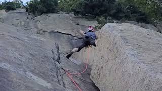
Silver / 은벽길 5.8 · full ascent · 냉감자 icegamza

Where to look things up
- Management and trails: KNPS live controls; identify the Bukhansan Dobong office and confirm named lines with management.
- Transport and parking: Dobong transport, the official FAQ and the parking operator cover the station, trailhead and parking separately.
- Route features: People and Mountain's fist-crack report explains the style and repeated cam sizes; an old refurbishment date is not a hardware guarantee.
- Guidebooks: Grades and route counts here come mainly from online databases; the guidebook is the authority. This article also checks the original book directly; carry a current route-specific topo.
- Climb: Rock Climbing in Korea, Dong-il Ryou and Jonn Jeanneret, Outdoor Global, first edition 2012. English with Korean names, covering selected roped crags around Korea; Seoninbong is on printed pages 238–241. Old transport and access information is not evidence of current conditions.
References
- Climb book listing
- People and Mountain: Stands With a Fist
- Monthly Mountain: Seoninbong rockfall and restrictions, 2025
- Seoul Alpine Federation: Reproduced 2026 thaw restrictions
- Dobong transport and FAQ
- Seoul Facilities Corporation: Dobongsan Station parking
- KNPS live controls and rock-use service
- Korea Meteorological Administration: Climate of Korea
- National Fire Agency: Public EMS and BMC product summary
- Mountain Project: International grades